|
|
Post by cheeesfreeex on Oct 18, 2015 19:56:26 GMT
Biddulph Moor mate! 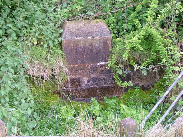 That's great. Do you know where exactly on th'Moor that is? {and what it says?} This un mucka. |
|
|
|
Post by Huddysleftfoot on Oct 18, 2015 19:59:56 GMT
That's great. Do you know where exactly on th'Moor that is? {and what it says?} This un mucka. ,+Staffordshire/@53.1214475,-2.1335432,15.5z/data=!4m2!3m1!1s0x487a43f41414655f:0xc96e07c15507df12 |
|
|
|
Post by cheeesfreeex on Oct 18, 2015 20:04:57 GMT
Mint. Settles an argument. More or less. Though the question of when a river actually becomes a River is difficult.  |
|
|
|
Post by NassauDave on Oct 19, 2015 3:41:02 GMT
Once certainty is that the arsehole of the Trent is in Burslem.
|
|
|
|
Post by Deleted on Oct 19, 2015 7:15:17 GMT
Name[edit]
The name "Trent" is from a Celtic word possibly meaning "strongly flooding". More specifically, the name may be a contraction of two Celtic words, tros ("over") and hynt ("way").[5] This may indeed indicate a river that is prone to flooding. However, a more likely explanation may be that it was considered to be a river that could be crossed principally by means of fords, i.e. the river flowed over major road routes. This may explain the presence of the Celtic element rid (c.f. Welsh rhyd, "ford") in various place names along the Trent, such as Hill Ridware, as well as the Old English‐derived ford. Another translation is given as "the trespasser", referring to the waters flooding over the land.[6] According to Koch at the University of Wales,[7] the name Trent derives from the Romano-British Trisantona, a Romano-British reflex of the combined Proto-Celtic elements *tri-sent(o)-on-ā- (through-path-augmentative-feminine-) ‘great thoroughfare’.[7] A traditional but almost certainly wrong opinion is that of Izaak Walton, who states in The Compleat Angler (1653) that the Trent is "... so called from thirty kind of fishes that are found in it, or for that it receiveth thirty lesser rivers."[8]
Course[edit]
The Trent rises on the Staffordshire moorlands near the village of Biddulph Moor, from a number of sources including the Trent Head Well. It is then joined by other small streams to form the Head of Trent, which flows south, to the only reservoir along its course at Knypersley. Downstream of the reservoir it passes through Stoke-on-Trent and merges with the Lyme, Fowlea and other brooks that drain the 'six towns' of the Staffordshire Potteries to become the River Trent. On the southern fringes of Stoke, it passes through the landscaped parkland of Trentham Gardens.[9]
Swarkestone Bridge
The river then continues south through the market town of Stone, and after passing the village of Salt, it reaches Great Haywood, where it is spanned by the 16th-century Essex Bridge near Shugborough Hall. At this point the River Sow joins it from Stafford. The Trent now flows south-east past the town of Rugeley until it reaches Kings Bromley where it meets the Blithe. After the confluence with the Swarbourn, it passes Alrewas and reaches Wychnor, where it is crossed by the A38 dual carriageway, which follows the route of the Roman Ryknild Street. The river turns north-east where it is joined by its largest tributary, the Tame (which is at this point actually the larger, though its earlier length shorter) and immediately afterwards by the Mease, creating a larger river that now flows through a broad floodplain.
The river continues north-east, passing the village of Walton-on-Trent until it reaches the large town of Burton upon Trent. The river in Burton is crossed by a number of bridges including the ornate 19th-century Ferry Bridge that links Stapenhill to the town.[9] To the north-east of Burton the river is joined by the River Dove at Newton Solney and enters Derbyshire, before passing between the villages of Willington and Repton where it turns directly east to reach Swarkestone Bridge. Shortly afterwards, the river becomes the Derbyshire-Leicestershire border, passing the traditional crossing point of King's Mill, Castle Donington, Weston-on-Trent and Aston-on-Trent.[9]
At Shardlow, where the Trent and Mersey Canal begins, the river also meets the Derwent at Derwent Mouth. After this confluence, the river turns north-east and is joined by the Soar before reaching the outskirts of Nottingham, where it is joined by the Erewash near the Attenborough nature reserve and enters Nottinghamshire. As it enters the city, it passes the suburbs of Beeston, Clifton and Wilford; where it is joined by the Leen. On reaching West Bridgford it flows beneath Trent Bridge near the cricket ground of the same name, and beside The City Ground, home of Nottingham Forest, until it reaches Holme Sluices.[9]
Newark Castle
Downstream of Nottingham it passes Radcliffe on Trent, Stoke Bardolph and Burton Joyce before reaching Gunthorpe with its bridge, lock and weir. The river now flows north-east below the Toot and Trent Hills before reaching Hazelford Ferry, Fiskerton and Farndon. To the north of Farndon, beside the Staythorpe Power Station the river splits, with one arm passing Averham and Kelham, and the other arm, which is navigable, being joined by the Devon before passing through the market town of Newark-on-Trent and beneath the town's castle walls. The two arms recombine at Crankley Point beyond the town, where the river turns due north to pass North Muskham and Holme to reach Cromwell Weir, below which the Trent becomes tidal.[9]
The now tidal river, meanders across a wide floodplain, at the edge of which are located riverside villages such as Carlton and Sutton on Trent, Besthorpe and Girton. After passing the site of High Marnham power station, it becomes the approximate boundary between Nottinghamshire and Lincolnshire and reaches the only toll bridge along its course at Dunham on Trent. Downstream of Dunham the river passes Church Laneham and reaches Torksey, where it meets the Foss Dyke navigation which connects the Trent to Lincoln and the River Witham. Further north at Littleborough is the site of the Roman town of Segelocum, where a Roman road once crossed the river.[9][10]
It then reaches the town of Gainsborough with its own Trent Bridge. The river frontage in the town is lined with warehouses, that were once used when the town was an inland port, many of which have been renovated for modern use. Downstream of the town the villages are often named in pairs, representing the fact that they were once linked by a river ferry between the two settlements. These villages include West Stockwith and East Stockwith, Owston Ferry and East Ferry, and West Butterwick and East Butterwick.[11][12][13] At West Stockwith the Trent is joined by the River Idle and soon after enters Lincolnshire fully, passing to the west of Scunthorpe. The last bridge over the river is at Keadby where it is joined both by the Stainforth and Keadby Canal, and also by the River Torne.[9]
Downstream of Keadby the river progressively widens, passing Amcotts and Flixborough to reach Burton upon Stather and finally Trent Falls. At this point, between Alkborough and Faxfleet the river reaches the boundary with Yorkshire and joins the River Ouse to form the Humber which flows into the North Sea.[9]
Migration of course in historic times[edit]
Unusually for an English river, the channel altered significantly during historic times, and has been described as being similar to the Mississippi in this respect, especially in its middle reaches, where there are a numerous old meanders and cut-off loops.[14] An abandoned channel at Repton is described on an old map as 'Old Trent Water', records show that this was once the main navigable route, with the river having switched to a more northerly course in the 18th century.[15] Further downstream at Hemington, archaeologists have found the remains of a medieval bridge across another abandoned channel.[16][17] Researchers using aerial photographs and historical maps have identified many of these palaeochannel features, one well documented example being the cut-off meander at Sawley.[18][19] The river's propensity to change course is referred to in Shakespeare's play Henry IV, Part 1:
Took me ages to copy and paste, err, I mean type that lot.
|
|
|
|
Post by cheeesfreeex on Aug 23, 2018 16:40:12 GMT
Going tonight to settle this debate.
Hopefully.
And to get 40 pints of Trent source water for an homebrew.
Hopefully.
|
|
|
|
Post by raythesailor on Aug 23, 2018 17:28:58 GMT
I live in a mid staffs village on the Trent, which section is ceartainly a river.
Over the years I have seen it change from a contaminated lifeless watercourse to the magnificent river full of wildlife and fish that it is today. As a Stokie born and bred it always amazes me how the stream that flows through the city is fed by numerous streams and brooks and it starts to turn into a river around Trentham and then becomes one of the major waterways in England flowing eventually into the N Sea.
|
|
|
|
Post by felonious on Aug 23, 2018 17:29:05 GMT
There was a programme on the BBC where a bloke traced the source and travelled (most of) the river's length in a punt, doesn't seem to be available at the moment, I'm sure it's been on fairly recently. www.bbc.co.uk/programmes/p00ydnf4Apparently there are 'several' sources all fairly close together up Biddulph way, from what I remember anyway, I'd like to see the programme again actually. I watched that, then he had to change craft as the river was too fast/big to carry on in the punt It's a shame he survived. His lazy contribution about Stoke was to find a shopping trolley in the concrete by the D Road when he obviously knew that a few hundred yards away were willow trees and kingfishers. |
|
|
|
Post by cheeesfreeex on Aug 24, 2018 14:15:43 GMT
I live in a mid staffs village on the Trent, which section is ceartainly a river. Over the years I have seen it change from a contaminated lifeless watercourse to the magnificent river full of wildlife and fish that it is today. As a Stokie born and bred it always amazes me how the stream that flows through the city is fed by numerous streams and brooks and it starts to turn into a river around Trentham and then becomes one of the major waterways in England flowing eventually into the N Sea. It's good to know that the nature is recovering, we're being more responsible regarding our rivers etc. The dam at Knypersley Reservoir completely changes the dynamic of the young Trent. It was once quite a substantial 'stream' way before Trentham. |
|
|
|
Post by cheeesfreeex on Aug 24, 2018 16:42:40 GMT
After being given bum steers in the Foxhound and erroneous info off several dog walkers we eventually located the 1935 inscribed stone, steps and well which marks the source of the Trent {Head of the Trent.}
The corner of a field near to Over the Hill, Biddulph Moor. The wiki entry is misleading.
Shame really, not easy to find and a pretty inauspicious location.
Overgrown somewhat dishevelled, it should be celebrated, festooned in garlands and tributes.
Couldn't get the billy can into it to collect enough water for an homebrew unfortunately.
Plan b for that.
|
|
|
|
Post by 3putts on Aug 26, 2018 17:46:06 GMT
As a part time angler I was astounded to see a shoal of silver fish(could have been bleak?) just south of the bridge you walk over to gain entrance to the gardens, the shoal was that big I am sure you could have walked over them to reach the other side.also last year I noticed some fairly big chub to the right this time which is very pleasing as it means the river has now recovered after years of pollution.
|
|
|
|
Post by Dutchpeter on Aug 26, 2018 17:53:04 GMT
As a part time angler I was astounded to see a shoal of silver fish(could have been bleak?) just south of the bridge you walk over to gain entrance to the gardens, the shoal was that big I am sure you could have walked over them to reach the other side.also last year I noticed some fairly big chub to the right this time which is very pleasing as it means the river has now recovered after years of pollution. You can see Chub in the Lyme Brook by Newcastle Town FC. |
|
|
|
Post by smallthorner on Aug 26, 2018 18:44:18 GMT
Biddulph Moor.
Onto Knype reservoir and through Norton Green.
Banky Brook (my childhood playground) is a drainage tributary and not technically the Trent.
It begins to get real significance in Stoke and Trentham.
|
|


